Following the Flow
UVA scientists and educators assess and improve water quality
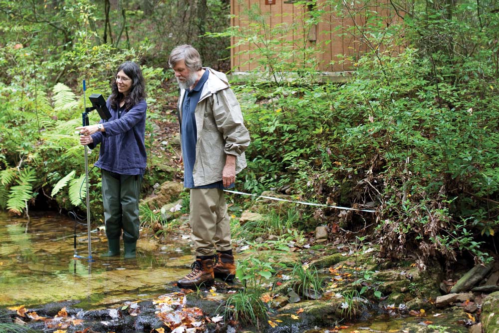
Suzanne Maben, gray-green waders hugging her legs, forges into the middle of Paine Run and, like a nurse monitoring a patient, records the vital signs of the stream.
The air is still and ripe with recent rain, and the sky is gray on this late-September day; the first blush of fall shows on the dogwoods and maples in the Shenandoah National Forest. As the water flows under the forest canopy, Paine Run seems transparent and pristine, the bedrock of pale quartzite visible below the surface. Small fish—sculpin and blacknose dace—occasionally dart among the submerged rocks and leaves.
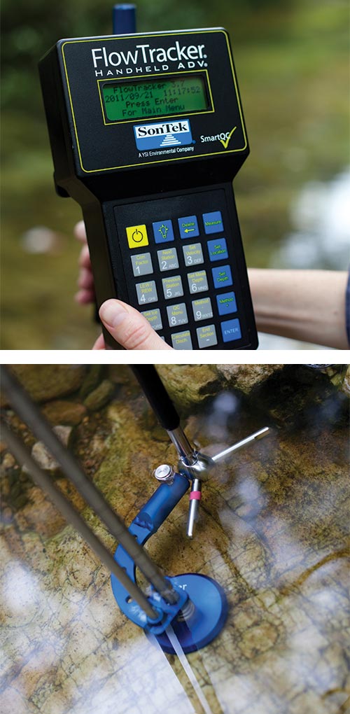
Maben runs a white measuring tape from bank to bank to gauge the width. Then she holds a flow meter—a metal rod with sensors and a digital readout—at several spots on the Blue Ridge stream’s bottom to track its depth and velocity. Finally, she moves upstream to take samples of the water, which, along with other data from the site, will be analyzed back at UVA, where Maben is a senior lab specialist in environmental sciences.
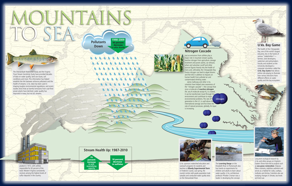
The sampling is a weekly routine that has been going on for years, part of a larger effort that has been under way for decades. The mass of information collected as part of UVA’s Shenandoah Watershed Study (SWAS) has had a critical role in shaping public policy on the environment and shedding light on trends in various ecosystems. It also provides a scientific benchmark for water quality, the first dot in a series that connects the trail of this precious resource as it flows from the mountains to the rivers to the bay to the ocean.
“The water quality doesn’t get any better as the water goes downstream. This is where it starts,” says Rick Webb, whose thick beard and ruddy cheeks create the impression of an affable mountain man.
In a sense, Webb, a senior scientist in the department of environmental sciences, is a man of the mountains. For years, he has shepherded much of UVA’s water research in the national park, national forests and elsewhere in the Blue Ridge. A fly fisherman when time allows, Webb coordinates the Virginia Trout Stream Sensitivity Study (VTSSS), which is done in tandem with the watershed project.
Trout streams are particularly important because brook trout, the only such species native to Virginia, are the last to go when streams become highly acidic; if “brookies” can’t survive, the water is in bad shape. But scientists look beyond fish—factoring in bedrock and soil composition, variations in flow and events like gypsy moth defoliation—when assessing water quality.
In the spring of 2010, more than 160 volunteers, organized by Trout Unlimited chapters in the state, collected samples from 384 streams. The findings, when compared with similar efforts in 2000 and 1987, contain some good news. Virginia’s mountain streams are recovering from earlier acidification on two fronts—concentrations of sulfates (sulfur in its water form) are down and many streams have greater capacity to neutralize acid, according to an analysis by former UVA grad student Janet Miller (Grad class of ’11). This improved health is linked directly to years of lower emissions from power plants, largely due to tougher emission standards that resulted from the Clean Air Act Amendments of 1990. SWAS data was instrumental in the passage of that legislation.
The story of that effort dates to 1979, when James Galloway, now associate dean of the College of Arts & Sciences, teamed up with two other professors to start a study based on a model Galloway was familiar with as a postdoc at Cornell.
They began on two streams—White Oak Run and Deep Run—in Shenandoah National Park, a partner in the study. Now, UVA regularly monitors more than 60 sites. Paine Run is one of five sampled weekly; it is one of three with sophisticated solar-powered equipment that records flow data and collects samples for analysis during storms and other high-flow events.
Over the decades, the information has accrued significance. “It’s like an endowment or a bank account, if you will—the more you put in, the more value it has later on,” Galloway says.
The data has been scientific ammunition for the EPA to illustrate that lower levels of pollutants in the air result in improved water quality in streams. “That’s what we’ve done with the 2010 study. That’s what that shows,” he says.
Research into emerging issues, such as mercury in streams and rivers, benefits from having the structure of SWAS and VTSSS in place, says UVA professor Todd Scanlon. His team studies mercury, which is so pervasive that, as of 2008, fish consumption advisories have been issued in every state in the U.S., encompassing 1.3 million river miles. Fish absorb mercury, and eating lots of certain fish can present health risks for some people.
In addition to providing data, SWAS has an academic value, providing sites for training “oodles” of students, Galloway says. “We’re harnessing the creative forces of smart people for the benefit of society.”
Back at Paine Run, Webb smiles slightly as he contemplates a similar theme. “In my view, it’s what an enlightened society wants and needs to do—being careful [with resources],” he says, rubber boots still wet from wading in the stream. “I am an ardent preservationist—not every scientist would want to say that. But I also believe in objective analysis and proceeding with understanding. The natural world is very complex, and we’re measuring just a slice of it here.”
Grassroots Effort
Seeding in coastal bays part of long-term research
Just as the seemingly pristine beauty of the Blue Ridge Mountains defines one point of Virginia’s water trail, the barrier islands off the Eastern Shore constitute another.
Climate and land use are the drivers of change in these ecosystems and shorelines. Some changes, like the shifting shorelines of the barrier islands, are incremental; others, like the wholesale loss of sea grass, are what scientists call “state change.”
Sea grass once flourished in the region, but disease and a hurricane dealt a fatal one-two punch in the 1930s. The grass was no longer there to filter nutrients from the water, to provide shelter for crabs, oysters and scallops, or to anchor sediment that otherwise muddied the water.
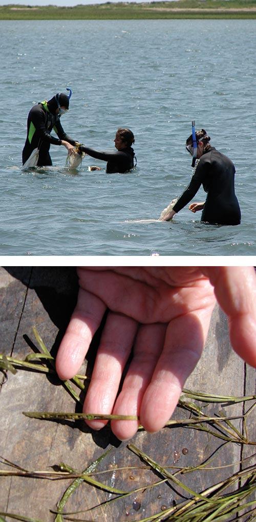
The effort took off in 2001, with the Virginia Institute of Marine Science seeding the sea grass and UVA scientists and students—donning wet suits and snorkels—monitoring how the system is changing. Initially, they seeded small plots in a 200-acre span; now, healthy sea grass covers more than 4,000 acres, and the species is propagating naturally, constituting the world’s largest sea grass restoration effort.
“I think this is a real success story,” says UVA’s Karen McGlathery, director of the Long-Term Ecological Research project, begun in 1986, that is now housed in the Anheuser-Busch Coastal Research Center on Virginia’s Eastern Shore. LTER’s goal, she says, is “to understand how long-term changes affect the ecosystems of this region.”
McGlathery says the sea grass is here to stay, under current conditions. “Now our main role is to understand the consequences of the return of this species.”
That means studying changes in water clarity, sedimentation and the return of marine species that depend on sea grass. One of the next steps along those lines, McGlathery says, is VIMS’ effort to restore scallops that once thrived in the region.
As with other research, computer modeling, led by UVA’s Joel Carr (Col class of ’99, Grad class of ’11), helps forecast changes, including how sea grass would be vulnerable to variables like water temperature. But the past is also a guide.
“This is an opportunity to turn back the clock to what it was like in the 1930s, when sea grass flourished in the coastal bays,” McGlathery says.
Getting a Fix on the Future
Computer modeling helps chart trends
Before smartphones, before tablets, before laptops, even before desktops—Jack Cosby and other UVA scientists were plunking away on keyboards in hopes of using computers to link science and society.
They used data collected through the Shenandoah Watershed Study, still in its early stages in the 1980s, not only to gauge the present but also to envision the future.
“We built a model to describe the acid rain effects on watershed streams, which grew out of our research in Shenandoah National Park,” says Cosby (Col ‘66, Grad ‘82). “There weren’t even PCs then.”
They reviewed existing computer models for the EPA and determined none were sufficient to help scientists or policymakers. “That’s when we came up with MAGIC. When you talk about where science meets society, MAGIC is a good instance of that,” Cosby says.
MAGIC now is used by scientists, regulatory agencies and policymakers around the world. It is an interactive computer program that allows users to enter data and determine the history of a site and, given certain variables, what’s likely to happen next in terms of acidification or nitrogen pollution. In addition to modeling, it helps monitor sites and ensure accountability for making improvements.
At another point in the water trail, University scientists and engineers are also mining the value of interactive computer programs. The UVA Bay Game, which uses computer simulation to show how decisions by various stakeholders affect the environment, has been cited as a leading model in the field. In September,
UVA became the first university asked to join the Aqueduct Alliance, a global consortium of leading water experts.
“What the Bay Game does … is help people understand that it’s not just about ‘me and my water,’” says UVA engineering professor Gerard Learmonth. “It’s about the bigger picture.”